Introduction | Last Chapter | Next Chapter
'Auyuittuq' - The Land that Never Melts
Northern Quebec to Hudson Strait
 Just to the northwest is the La Moinerie Crater, another terrestrial blemish from the distant past. They stand out very distinctly in the north, above the tree line. A little further northwest is Kujjuaq, a busy port on Ungava Bay, with an FSS and where 100LL could be had for $1.50CDN a liter. The 6,000 ft paved runway was being rebuilt but the 5,000 ft-gravel strip was used by prop and jet traffic. I watched the clouds of dust billow up as one jet departed. Two lonely looking Murphy Rebel homebuilts were tied down near the taxiway. The owners could not get their pilot licenses and so there they sat for the last couple of years. Being this far north, flight service could not give a definite weather picture beyond a hundred nautical miles northwest, but I was planning on over-flying the communities of Aupaluk and Kangirsuk along the coast.
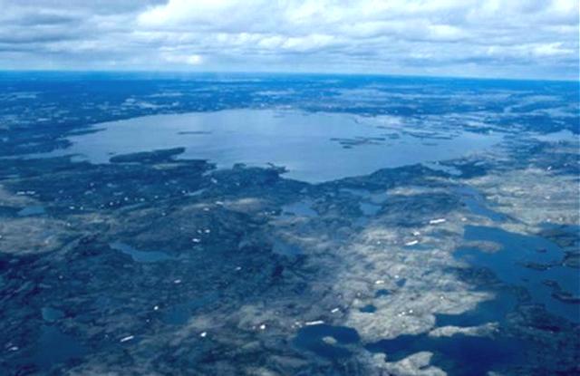
This region of Quebec is called Nunavik and like the territory of Nunavut, they speak a language called Inuktitut (ee-NUKE-tee-toot ). Dan, a young Inuit fellow who was filling my tanks, gave me a short lesson on place names, their meaning and pronunciation. Some other men looking over my Husky spoke of a muskox herd just to the north, so I departed towards the next community, looking along the coast of Ungava Bay, but I did not find any of them. Over Kangirsuk I took up a more westerly heading out over the barren land, in search of yet another astrobleme (meteor crater). The clouds rolled in from the northwest, but Mitch had told me that convective weather does not form this far north. There was no fear of thunderstorms, but the ceilings were dropping low to the ground and I found myself flying over the top of the cloud layers at times. 130 NM across rock and ice, no trees or any sign of habitation, the Chubb or Pinqualuit Crater (61°17'N, 73°40'W; rim diameter: 3.4 km Age: 1.4 million years) is very distinctive. The raised walls enclose a circular lake with water that is alleged to be of the highest clarity found anywhere in Canada, probably because nothing drains into the crater. On this June 30, the lake was still frozen so I circled awhile taking several dozen pictures and video, then headed north toward Hudson Strait. The gravel strip at Kangiqsujuaq ("Kang-ga-sue-je-wack") is on a plateau high above a town that sits along side Wakeham Bay. It was windy but I could not find anywhere to tie down in the rock so I attached a rope from the tail of my Husky to the base of a post, keeping the wind at its tail. An Inuit woman and her husband drove up and said I could use the phone. The door latches on the Terminal building had been taped over so they could not be locked so when they left, I decided to spend the night at the airstrip. I called Bert in Iqaluit and was informed that the weather was not good so I phoned FSS back at Kujjuaq to close my flight plan, I would not be crossing Hudson Strait today. Late afternoon turned to evening as I realized that it wouldn't be getting totally dark tonight. Alone in the airport office building, I ate and then paced the small room back and forth, looking at the old photos on the wall and reading their stories. The wind outside was cold and the low clouds and fog rolled in from Hudson Strait just over the hills to the north. I confess that this was a low point of my trip, asking myself what the heck I was doing here so far away from home. Looking back, the times you remember most fondly are those when you felt so vulnerable.
Finding a room with no windows, I rolled out my sleeping bag on the floor and tried to get some rest. At 02:30 I awoke to the sounds of doors opening and closing. In the north, in summer, when it never gets totally dark, the people are up at all hours, and someone needed to use the bathroom. I could not get back to sleep, the weather looked better, so I called FSS, and made a flight plan to Iqaluit. Lifting off at 03:30 July 1st, I climbed north to cross 90 NM of very cold water, the temperature of Hudson Strait never goes above 2 Celsius. There were large areas of sea ice below, but the engine just purred along as I climbed above the clouds to 10,500 ft. After what seemed a long time, my GPS told me I was finally crossing the south coast of Baffin Island. Dropping through a hole in the clouds, I found the strip at Kimmirut tucked beside some high rocky hills. I had planned on meeting a friend of Bert's in Kimmirut, Sam Pitsiulak, but it was too early to be knocking on doors. Sam was a world famous Inuit carver who had also built his own ultralight.
|